In this space information on the sundials which I know of or have seen in person will be posted. 說明一些日晷的基本原理。介紹一些我見過的日晷。 希望大家對日晷有更正確的認識,都能製作正確的日晷。 General principles and examples of sundials will be given here with the hope that sundials be read or made correctly.

2008年12月25日 星期四

南投 猴探井 日晷 A surprise dial at HouTanJing, NanTou, Taiwan

中文讀者請至 http://blog.xuite.net/nycl.chiu/blog/21498077

There was someone posting a picture of horizontal sundial in his web page saying that it was right on the grass behind the visitor center of BaGuaShan scenery park, ZhangHau. From the picture I was sure that the sundial was designed by an expert. There were hour lines as well as calendar lines. The nodus was the finger tip of a boy sitting on the high end of a seesaw while other three boys were on the low end touching the ground. Such a beautiful design for sundial is what I must see in person.
Today is the winter solstice day and the sky is blue. A perfect day to observe a sundial with calendar lines. My wife and I got up early and drove down to BaGuaShan park. Not far from the entrance of the park, about one km, we passed a natural park, which concerns mostly migratory birds who use that area as a rest stop in their journey. Making a right turn along the road, we found a parking lot. The lot keeper pointed out the way to the visitor center to us and said it would take only 5 minute walk to get there, so we parked our car. The way to the visitor center was uphill a little bid. It took 15 minutes for us to walk there.
There was an open space besides the visitor center building. From there one can view the whole ZhangHau city below, so we went over that way trying to reach the grass ground behind the building. The open space turned out to be an open theater but there was no grass ground behind the building. Of course, no sundial either. Astonished, we backed up and got in the visitor center looking for help.
There were five service persons on duty but none of them knew where the sundial was. Even all of them denied that a sundial existed in visitor center area. We were very depressed. Suddenly a service lady (volunteer) said: “I know. The sundial is at HouTanJing, not here. There is another visitor center of BaGuaShan scenery park at HouTanJing.” HouTanJing? I have never heard of that place. The lady unfolded a park map and point out the location of HouTanJing. The park area goes north-south; Zhang Hua is on the north edge and HouTanJing is on the lower quarter. “The road in front of us is road 137. You take south and follow the road. After few turns you’ll see a water supply. Make a left turn there and you‘ll be on road 139. Driving all way down, you’ll see the sign of HouTanChing.” (Ching should pronounce same as Jing. They tends to mean the same word in Chinese.) In my mind, the park had an area around a hundred acres only. But that was the impression I got more than two decades ago. The new map before me showed totally different things. I asked carefully: “How far is that?” “Half hour of driving if you know the road.” I took another look at the map. Yes, she must right. HouTanJing was about 25 km from where we were standing and only 5 km west from NanTou city.
When we arrived HouTanJing, we saw a small house there. It was a visitor center, but not that of BaGuaShan scenery park. We went in the house and found nobody inside. There was one service man in his sixties outside by the vending machine and he was our only hope. Knowing what we were looking for, he said:”The sundial is just over there, only a few steps down the stairs. Today you have to stand on the ‘12/22’ mark on the calendar line.” Wau! I was surprised. Although he did not make it right, it was not easy for an ordinary countryman to knew that today the shadow of the kid’s finger would fall along the ‘12/22’ calendar line. I was so anxious to see the sundial that I did not give him one more minute to introduce it to me. I ran to the stairs with the hope that there was a grass ground in front of them. But I did not have to walk down further, the sundial could be seen right from there. It was a sundial, an analemmatic dial! I was shocked again.


We didn’t mind that it was not the dial we were looking for. But where is that horizontal sundial? We checked web sites again after we came home. It turned out that the information we got the first time was wrong. The sundial is in the visitor center of the natural park where we passed at the beginning before we parked our car in the lot!

2008年12月9日 星期二

垂直、偏向垂直 和地平日晷的小時線 Hour Lines for Vertical, Declining Vertical and Horizontal Sundials

假設有個赤道日晷面(F1),其南面的小時線分布如Fig. 1,每小時15度,其晷針垂直於紙面。如果將此圖用平行於晷針的光投影至一平面( F2),其形狀將視兩平面相互之間的角度而定。
Fig. 1 shows the hour lines on the face (F1) of an equatorial dundial. Those lines are separated equally by 15 degrees. The gnomon, which is not shown here, should be perpendicular to the screen. If some parallel light is cast through this diagram onto a plane (F2), the shape of the new diagram formed by the shadows those lines varies according to the angle between F1 and F2.
若F2垂直,F1單純向南傾斜一角度M,則F2上之投影結果必然左右寬度不變,上下長度變長。以各自晷心為原點,在F1上某一點P1(x1,y1)投至F2上成為P2(x2,y2)點;其中x2 = x1, y2 = y1/cos M。就是Fig. 1 中所有的點(線)相對於6-18線的距離都同時向下移動,新的距離是原來距離的1/cos M倍,以形成Fig. 2。
If F2 is kept vertical and F1 is simply declined due south with M degree, then the resultant new diagram must be longer in height but without any change in width. Taking each dial center as its own origin, point P1 (x1,y1) on F1 generates point P2(x2,y2) on F2 with x2 = x1, y2 = y1/cos M. That means all points in Fig. 1 move downwards, referred to 6-18 line, to their new distances, which equal to the old distances multiplied by 1/cos M, to yield the shadow diagram, such as Fig. 2.
Fig. 2 是個M = 40 的例子。因赤道日晷傾斜40度,所以此圖即是北緯40度適用的垂直日晷小時線圖。晷針必與投影光線平行,故與水平面成50 (= 90 - M)度。
Fig. 2 is a result of M = 40 degrees. It is also the hour line diagram for a vertical sundial face on latitude 40N. Its gnomon ought be in the direction of the casting light, so it has an angle of 50 ( = 90 - M) degrees to F2 in this example.

如果將垂直面F2逆時鐘旋轉D度,D在此稱為偏向角,形成偏向垂直面F3,此時F1上的線條會在F3面上產生新圖樣,如Fig. 3。其小時線的角度分配決定於緯度和偏向角。
If the vertical plane F2 is rotated D degrees counterclockwise, (this rotation is called declination), plane F3 results. Those shadow lines on F2 are now on F3 and may have the hour line pattern as shown in Fig. 3. The pattern depends on latitude and declination.


Fig. 4說明了P2和P3的關係,其中藍色線是投影光線,距水平面角度 φ。P1和P2的關係已如前述。 P1 和赤道日晷原點(晷心)的關係是:x1 = sin ha, y1 = cos ha, ha = 時角 = (12 - hour) × 15。故可得垂直偏向日晷的時角h12公式
x3 = x1 ÷ cos D
y3 = y2 - x2 × tan D × tan φ
= y1 ÷ cos φ - x1 × tan D × tan φ

tan h12 = x3 ÷ y3
= cot φ ÷ {cot ha × cos D ÷ sin φ - sin D}


The mathematical relations between P2 and P3 are depicted if Fig. 4, where the blue line represents the cast light with an angle of φ from horizon. Those between P2 and P1 are given above. With x1 = sin ha, y1 = cos ha, and ha = hour angle for equatorial dial = (12 - hour) × 15, we have the formula for the hour angle h12 for declining vertical dial as
x3 = x1 ÷ cos D
y3 = y2 - x2 × tan D × tan φ
= y1 ÷ cos φ - x1 × tan D × tan φ
tan h12 = x3 ÷ y3 = cot φ ÷ {cot ha × cos D ÷ sin φ - sin D}

如果將垂直面F2向下轉成地平,形成平面F4,P1在此新平面F4上投至P4(x4,y4)。則 x4 = x1, y4 = y1 / sin φ,φ為緯度。將Fig. 1赤道日晷小時線各端點的(x1,y1)換成(x4,y4),再由這些新的端點連線至晷心,即得地平日晷之小時線。
If the vertical plane is reclined so to give a horizontal plane F4, the shadow of P1 on F1 casts on F4 at P4(x4,y4) and x4 = x1, y4 = y1 / sin φ. That is
x4 = sin ha
y4 = cos ha / sin φ
Connect P4 points obtained with proper ha to the dial center with straight lines. These are the hour lines for horizontal dial at latitude φ.

2008年11月22日 星期六

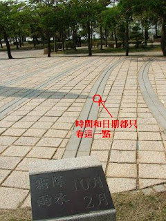
台灣 台中市 台中都會公園種子日晷 Sundial in Taichong Municipal Park, Taiwan


台中都會公園在西元2000年建了一個日晷,其形狀構思於種子發芽,故得名「種子日晷」。此日晷高有1025公分,相當巨大。其投影的地面鋪有石塊,並有十三條很好的二十四節氣日期線。因為日晷高,雖石鋪的地面相當大,只能接受正午前後約兩小時的影子。
This sundial was built in 2000 AD. The highest point, the nodus of the sundial, is 1025 cm from the ground. The face has a shape of round which covers 13 calendar lines but only 5 hours of daylight at most (on equinox line) without hour lines.


此日晷用來指示時間和日期的是那芽的尖端點,而非那明顯粗壯的芽身。用術語說,那芽的尖端點稱為節點。只用節點而不用芽身,是一般民眾不熟悉的方式。此其一。
受影的地面上沒有時間線,只有一些標示點;11到13點每點鐘只分配到4個,10點和14點各只有兩個。這些標示點不標示太陽時間,它們標示標準時間。因為兩種時間隨日期有不同的時差,標準時間線在受影面上是個扭曲了的環線,具有近8字的形狀。這樣的曲線只用4個點,實在不足以顯示。此其二。
For 11, 12 and 13 hour each, four stone hour marks are embedded in the face ground to indicate the standard time. The standard time is related to the solar time by equation of time. On dial face, this relation can be plotted and has a shape of twisted circle, or the figure of 8. To show the figure of 8 on this dial face construction, it needs probably 50 marks, but only four were placed. Much too few!
夏至正午12點的節點影子是各12點裡最接近晷體的。事實上,對中都公園來說,夏至正午12點的節點影子幾乎就在子午線上。但是它的標示牌卻偏在下午許多。此其三。
From the photos we took, it is clear that those 12 o'clock marks were misplaced.
由於以上三點,一般民眾對它只能搖頭;不是說它錯了,就是說自己看不懂。
中都公園的整體規劃十分明顯的具有重要的教育功能,日晷是其中的主角。可惜此日晷受影面上不做小時線,不論太陽時間或標準時間,不但失去原應有的功能,還引起更多的疑惑。

2008年11月16日 星期日

雲南昆明安寧縣溫泉鎮曹溪寺 方位日晷 Azimuth Sundial at CaoXi Si, KunMing, YunNan, China


安寧縣溫泉鎮是個小鎮,因有清澈溫泉而得名。本地人口不多,來泡溫泉的卻不少。鎮邊西方山麓上的曹溪寺,始建於宋代,亦因有泉水而知名。寺名看起來與禪宗有關,但缺文獻佐證。七百年來,該寺走過幾次興衰,目前寺內古舊文物、建築尚能維持,是相當不易的。去年我得到一本1958年初的介紹日晷的書。其中提到曹溪寺有個日晷,並且附了畫像。因日晷面盤上有七條半圓線,線旁註明12中氣名稱,圓心豎著垂直的錐狀投影桿,該書作者認為那是日圭,並且認為投影桿頂點的影子在各中氣那天就會沿著相對的半圓線移動。我很想知道中國古時候使用怎樣的日晷,可惜只見到北京故宮裡的赤道日晷。這一個是寺廟裡的,又不是赤道式,所以就對它留了意。年底時正好到昆明一遊,便由親戚帶領我二姊與我前往。

入了山門,向收門票的姑娘打聽日晷的位置,原來就在大殿前邊場地中央。我們很快就找著了。趕快上前拍照。駭然發現這不是古物,而是民國32年製的,只比我大兩歲。它也不是日圭,明明白白的是一個少見的方位日晷。旁邊正好有位和尚在向年輕學子論法,見我繞來轉去盡是對日晷拍照,便過來告訴我們這是當年交通部派駐云南協修滇緬公路人員中,有八位住在曹溪寺,後來就留下這個日晷。我見日晷面上刻著「曹溪日晷交通部技術廳機務室製 中華民國三十二年四月」,想必當年是以政府名義贈送寺方的。那麼當年駐寺八位中顯然有地位不低的官員;能夠並且願意設計方位日晷,顯然是具理工背景人士。只是,怎麼會把送人的禮物裝在大殿正前的樹下?這犯了兩個錯誤:對主人不禮貌,以及忘記了日晷需要的不是樹蔭而是光天。面盤邊緣有些破損,投影的銅桿顯然是重裝的。和尚說:「這日晷原來不在這位置。日晷在文革期間被拆毀,改革開放後又因是文物而得以復原。由文物保護單位重裝於此。」原來是這樣,難怪!
面盤上只在各中氣日做了時間(幾點鐘)標誌短線,而且所欲顯示的是「太陽時間」。從太陽時間換成手錶時間,不是每個人都會的。日晷旁邊缺少時差表,也沒有經度資料,一定會有許多人因這日晷而困惑。真是可惜。我心裡正這麼想著,和尚靠過來瞧著時間線,說:「這時間,有些誤差。」我正忙著拍照,若要同他解釋,手邊又無資料,只好向他笑笑,感謝他的好意。離開之前,拿出指南針,放在12點線(子午線)上。指南針相較子午線偏了2、3度。這在正常範範圍內。回到家就可以仔細研究了。我們拍照時是冬至前一星期的手錶時間11:50,用時差、經差修正之後,應是10:45。而日晷顯示9:50。這中間差了55分鐘。怎麼可能?哪裡出錯了?再三檢查了各種可能因素,還是無法解釋。最後一著,自己畫個圖看看。將電腦得出的圖形重疊在相片上,立時就知道原因:日晷上的時間標示線的位置是錯誤的!我順手用硬紙盒和原子筆芯做了一個昆明使用的方位日晷,放在陽台上天天觀察。為了避免每次觀察後的時差校準手續,我在面盤上畫的是校準過的時間,即標準時間線。經前後一個月的觀察,沒有不準的。

再來看那計算的時間線與日晷相片的重疊圖,得知該日晷9:50位置對應的是10:28。這和應有的還差17分鐘。剩下的一個可能原因就是它的方向不對:12點線不在子午線上。從那天其他的相片檢查,看出其12點線與地面磚塊平行。也就是與大殿屋簷平行。從GoogleEarth的衛星圖得到屋簷方向是北偏東約4.5度。於是將相片順時鐘轉了4.5度再與計算圖重疊。這時日晷上的9:50正好相對應圖上的10:45!
The sundial was given to the monastery, CaoXi Si, in 1943 and removed from its original place in the 60's. Then a few years ago it was restored at present place by the county government.
It is an azimuth dial with seven calendar lines, the summer solstice is the innermost and the winter solstice is the outermost. However, its hour lines were calculated totally wrong and its N-S line, or the 12 o'clock line, is deviated with 4.5 degrees clockwise!

關於我自己

我喜歡金剛經和維摩詰經。希望大家願意對我多指導。從清大化學系退休以後又對日晷生了興趣。很願意將我所知的日晷與你分享。